
One of the many things my sister and I share is a love for the mountains. So, when she booked a trip to visit us, we knew that hiking would be a central theme of our activities. Fortunately, with the alps at our doorstep, there was no shortage of options, and we mapped out a week long itinerary that led us through the Swiss and French alps.
We quickly dubbed the week our Summer Hikecation, and spent a full 6 days exploring the best trails we could find. Along the way, we saw some of the Alps most iconic peaks – the Eiger North Face, the Matterhorn and Mont Blanc. We traveled via car, train, funicular, cable car and put a lot of miles on our trail shoes. Here’s a breakdown of how we spent the week, although in this case, I think it’s definitely true that the pictures tell a much more compelling story than any words could.
Day 1: Geneva
Bonnie arrived on Saturday evening, so our first full day was dedicated to jet lag recovery and seeing the sights around Geneva. One of our favorite things about living here is how walkable the city is. Our apartment is right in the center, so we set out on foot to explore the lake front, by way of Old Town. We walked along the Eaux Vives side of the lake first, before taking a short boat ride across to Paquis (the boat is part of the normal public transit system, so a day pass or single ride ticket will get you across) on the other side of the lake. From there, we stopped by the U.N. to see the Broken Chair monument, and then walked back through the Botanical Gardens. We capped the evening off with a run along the Arve river and through the old Italian style neighborhood of Carouge. Then, it was time to pack our bags and get ready for an early wake up call. The Alps were calling our names!

Day 2: Geneva to Grindelwald & Hiking First to Burg
We set off early on Monday morning, skirting around Lake Geneva en route to Grindelwald, a small mountain town in the Bernese Oberland region of Switzerland. Matt and I had visited once before, just for a night, but were excited to go back and explore more of this beautiful valley. The drive took about 3 hours, with some beautiful scenery along the way. Once there, we parked the car and set off on our first hike of the trip.


Our original intent had been to hike to a mountain hut called Faulhorn, but we were informed at the cable car station that this hike “wasn’t possible”. While Bonnie was sure it was quite possible for us to make our way up the mountain through a little bit of snow, we learned that the hut, which has a restaurant and accommodation, wasn’t yet open for the summer season and so they close the trail until it’s in operation again (on June 30 for 2018). We quickly took a look at the trail map, and charted a new course, which kept us at slightly lower altitude, but still covered some beautiful trails.
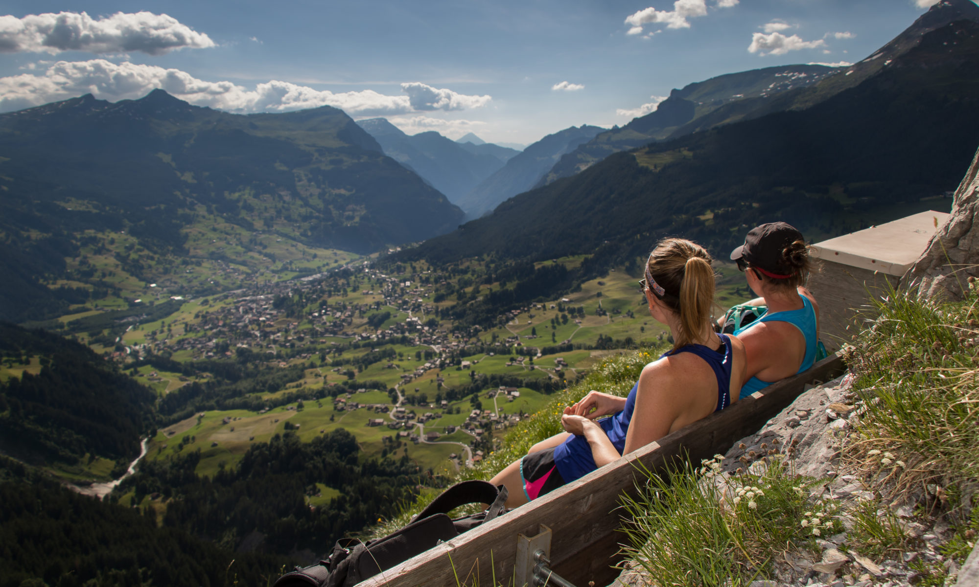
In order to start the hike, we took a cable car to the “First” station, which sits at 2,167m (7110 ft) elevation. Our first stop was the Cliff Walk, a metal suspension bridge which wraps around a rocky cliffside, leading you up to a platform which overlooks the valley below. As we ascended, a thick fog rolled in, which obscured our view, but made for an eerily beautiful experience in and of itself.


Fortunately, as we set off from First, the clouds began to clear, and soon we had expansive views over the green hillsides and rocky cliff faces which surround Grindelwald. Our first stop along our hike was Lake Bachalpsee. From First, there are two paths to get there. One takes a high route along a wide gravel path, and the other takes you down and back up again along a narrower, more isolated path. While both have nice views, we chose the lower path in order to get away from the crowds. After passing by the lake, we continued along a path that led us West in the direction of Bussalp, a small mountain restaurant with a trail connecting back down the mountain and into town. Along the way, we made the first of many snow crossings, managing to stay on our feet most of the time.


Before heading down to town, we made one last climb up to a peak called Burg. The path to this peak wasn’t quite as well worn, but we made our way though some wildflower patches, and up a steep hill before enjoying lunch with a view that stretched over Grindelwald as well as the surrounding towns of Wengen and Lauterbrunnen.
From there, we made the long trek across many a cow pasture and back into town. Needless to say, between the nearly 35,000 steps and day 2 of jet lag for Bonnie, we were all ready for a good night’s sleep to get us ready for our second day of hiking.


Day 3: Glecksteinhutte
For our second hike, we set our sights on a glacial valley on the back side of Grindelwald to a mountain hut called Glecksteinhutte. While this hike isn’t well advertised throughout many of the tourist information packets, it ended up being one of the highlights of the trip. The trail is #77 on the Jungfrau hiking map, and was well marked all the way from the starting point at the Hotel Wetterhorn (which also has a large parking lot).
From the beginning we were climbing, and understood why the woman at the tourist office had been keen to make sure we had good hiking boots. The trail is rocky and exposed along the mountainside as it winds up the valley toward the Grindelwald Glacier. With every turn, the scenery seemed to change, making the climb well worth it. The trail led us under a waterfall, in front of a glacier, through some beautiful wild flowers, and past some friendly mountain sheep before we finally made it to our destination. Here, we stopped for a relaxing lunch, and tried our hand at slack-lining, all the while enjoying some incredible views.


It was along this hike that we learned, by way of a perplexing trail signpost, that the German word for Hiking is Wandern, and that hiking trails are described as Wanderweg’s (or Bergwanderweg’s – Berg = mountain, wander = hiking , weg= trail). I think we can all agree that “wanderweg”, is a much more fun word than “hiking trail”, and the fun only continued when we learned that trails are often marked with descriptors such as abventureweg, panoramaweg, huttenweg, etc. Basically, we are now fluent in German hiking trail descriptions.
Day 4: Grindelwald to Zermatt
On Day 3, we said goodbye to Grindelwald, and headed toward the car free mountain town of Zermatt. We would drive the first stretch of the journey, before leaving the car in a town called Visp, which has direct train routes into Zermatt every 30 minutes. Along the way we took in some views, scrambled up a boulder field and tried our best to avoid extreme carsickness as we zigzagged down millions of mountain switch backs.
Our first destination in Zermatt was a mountain hut called Fluhalp, where we would spend the night. To arrive there, we took a combination of a funicular train, a cable car and a short hike.Any lingering carsickness abated as we stepped out of the cable car into the fresh mountain air, and shamelessly ate Toblerone chocolate against the backdrop of the Matterhorn.


From here we passed Stelisee lake, which famously reflects the Matterhorn at sunrise and sunset, and then followed the sign for the Huttenweg, which led us to our accommodations high above Zermatt. We dropped off our backpacks, settled in and took a walk around the surrounding area to take in even more amazing views before heading downstairs for the nightly dinner service. We enjoyed some delicious german beer, along with soup, salad, chicken and an apricot kuchen.


After dinner, we got to enjoy one of the real benefits of staying on the mountain, which was that we could watch the sunset over Stelisee lake.
Day 5: Adventurewegs and Seen-Wegs in Zermatt
We woke early to the sun streaming in the windows of our room in the hut, and made our way downstairs for a breakfast of DIY boiled eggs and granola. With my first trail race just a few days away, and the Matterhorn beckoning us, it seemed like as good a time as any to break in my new shoes, so Bonnie and set off for a short run, where we ran into some Marmots and managed to snap a few (hundred) more pictures of the Matterhorn.

After returning and packing up our bags, it was time to make our way down the mountain. After assessing our options we opted for a trail that would lead us down a ridge, and eventually take us back to the Blauherd cable car, where we could meet up with the famous 5-lakes trail (5-Seenweg). As we made our way, we were happy to learn via the signposts, that we had selected an Abventureweg. On the way down, we crossed several snow fields, and traversed some rocky terrain, all the while continuing to catch glimpses of the Matterhorn and surrounding mountain range.


We capped off the day’s hike with a 2 hour loop which led us by the remaining 4 lakes. This hike has a much wider path and a lot more tourist traffic, but still awarded us some great views. From there, we made our way back down the mountain to Zermatt for a relaxing evening.


Day 6: Zermatt to Chamonix
We woke on Day 5 to another clear, beautiful morning, and enjoyed a delicious breakfast of bread, eggs, yogurt and homemade jams at our hotel before making our way back to the train station and the car. We were off to our 3rd and final alpine destination, and our second country – Chamonix, France.
Only an hour from Geneva, Matt and I have made the trip to Chamonix many times, but with summer finally in full swing, we were itching to explore even more of the trails here. Bonnie and I were also entered to compete in the 10k event of the Mont Blanc Marathon weekend, so our time here was sure to be action packed.
On the way into town, Matt dropped Bonnie and I off at the base of the Flegere cable car station, and we set out on one last Abventureweg for the week. From Flegere, we made a loop that led us past Lac Blanc and the Lacs de Chésery. Along the way, we got in a few more snow crossings, traversed some ladders and survived a few stand offs with Ibex mountain goats. Back at the cable car, we met up with a trail that led back through the trees and into town, and got in a little more trail running practice.


 Back in town, there was no shortage of energy or hydration vests, as the marathon weekend has already kicked off with the 90k ultra race. The runners had set off at 4AM, and steadily made their way to the finish line starting from 2:30PM all the way thought the night until the 4AM cutoff on Saturday morning. We grabbed dinner at the Micro Brasserie du Chamonix (a great place to grab a burger and a beer on the outskirts of town), picked up our race bibs, and hung out at the finish line for awhile, cheering on the headlamp clad finishers as they completed their races.
Day 7: Race Day in Chamonix!
Our final day of the trip was focused around the 1PM start of the 10k race. We grabbed breakfast at our favorite coffee shop, La Jonction, and wandered through town a bit, before heading to the start line. This would be my first trail race, so I wasn’t entirely sure what to expect. Throughout the race, I had moments of “this is great!” and “this is the worst!”, but the overall consensus was that it was a great experience and definitely something I want to do more of. Bonnie finished strong, coming in 8th place overall, and I think it’s fair to say we both earned the post race spread of fancy cheese, chocolate, salami and baguette that reminded us, lest we forget, that we were, indeed, in France.


 We spent the next few hours wandering back through town, and soaking in the last of our week in the mountains. Finally, it was time to head back to Geneva, take some much needed showers and get Bonnie packed up for her trip back to the U.S.
I really can’t put into words what an incredible week it was. One of the toughest parts of living abroad is being away from loved ones, but that means that one of the sweetest things is being able to share and explore your new home with the people you love. Here’s to the next adventure!